Showing posts with label Google Transit. Show all posts

Tuesday, 12 July 2011

Chennai and Hyderabad local bus services board Google Transit

I am happy to announce the addition of local bus services in Chennai and Hyderabad to Google India Transit. This launch will help millions of commuters and visitors in these metro cities to explore public transportation options as they search for directions or locations, and encourage alternatives to driving. This information is available both on Google Maps and Google Maps for mobile enabling users to access the service even on the move.

How to make the best use of Google Transit

I was recently in Hyderabad for a meeting and had a couple of hours to spare. I always wanted to visit and know more about the famous Salar Jung Museum. I did a quick search on Google :


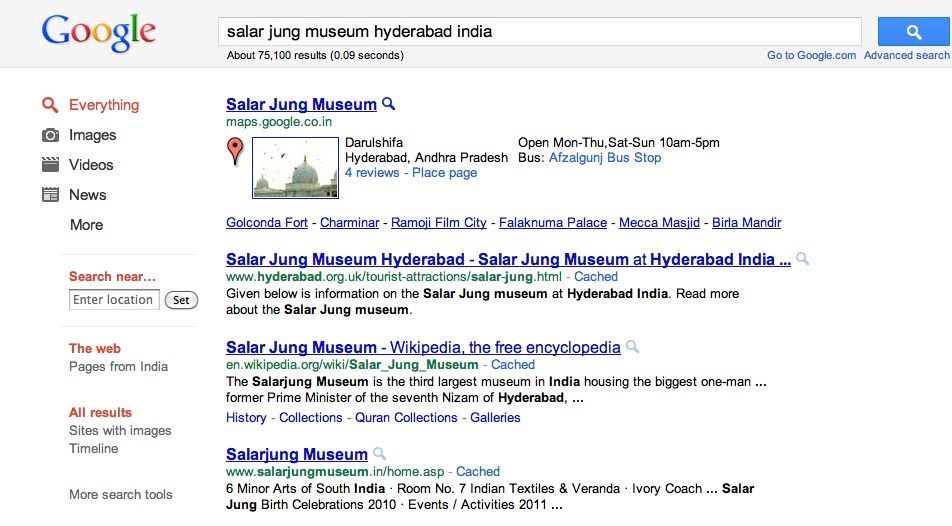
A click on the map link in the first result took me to the place page of the Museum on Google maps :


Place page has lot of information about the museum including the nearest public transit stop and an easy way to plan your trip
  1. Click the “Directions” link below the address line
  2. Enter your location or the place from where you need directions in the field “A”. For me it was “Hitech city Hyderabad” and click on the “Get Directions” button
  3. Press on the bus icon (next to the car icon) and get the detailed trip plan using available public transit options

Alternatively, one can also get the directions by searching “Hitech city Hyderabad to Salar Jung Museum Hyderabad” directly on Google Maps. So next time whenever you are in Delhi, Mumbai, Bangalore, Chennai, Pune, Hyderabad or Ahmedabad, use Google Transit to plan your trip and help reduce emission and congestion in our cities.

Monday, 23 May 2011

Ride on Delhi and Ahmedabad buses with Google Maps

More people, in our metro cities, use local bus services to commute than any other transport network/medium. Inspite of this, the availability and dissemination of route and schedule information of these service have tremendous scope for improvement. Furthering our goal of expanding transit coverage of Indian cities, we are glad to announce the addition of DTC (Delhi Transport Corporation) and AMTS (Ahmedabad Municipal Transport Services) bus services to Google Transit. These cities join Mumbai, Bangalore and Pune bus services that are already available apart from 450 cities globally.

How to make the best use of Google Transit

Not only is it very easy to plan your trip, but you can also find a trip that involves a) fewer transfers b) less walking or c) uses a particular type of transit service (trains or buses), using Google Transit
  • Search for information to reach from Place A to B on Google Maps, the results will show a map with the possible route and driving directions for the commuter
  • Choose the transit option by clicking the train icon (next to the car icon)
  • Commuters would get first hand information on best available multi-modal routes and step by step directions including frequency, and travel duration for each leg of the trip in text and on the map.
  • You can also refine the trip options by clicking on the “Show Options” link that appear below destination point B field
Below is one example. You are visiting a friend who stays in Mayur Vihar phase I in Delhi and you would like to visit Red Fort using the bus.


Your friend instead suggests taking Delhi Metro to go to Red Fort and bus for the return journey. Its very easy to plan this using Google Transit, simply choose the preferred transit service to “Subway” and hit “ Get Directions” !


So next time when you want to plan your trip whether from New Delhi Railway Station to Vasant Kunj or from Ahmedabad railway station to IIM, explore all the public transport options using Google Transit and adopt an environment friendly way to commute.


Thursday, 31 March 2011

Public Transport Information for Mumbai arrives on Google Maps

Is your Mumbai experience authentic without having to hop a red BEST bus or having to board a crowded local train ? Its hard to imagine aamchi Mumbai without its trains and buses. Knowing that life in Mumbai revolves around trains and buses, it gives us immense pleasure to announce the availability of BEST Bus and Mumbai Local train routes and schedule information on Google Maps. This information is available both on desktop and on mobile for millions of commuters in Mumbai, arguably the most used public transportation network in India. Transit on Google Maps already includes information for Delhi Metro, Bangalore and Pune bus services in India in addition to 450 cities worldwide.

The easy access of this service helps commuters and tourists find their way seamlessly around the city using both trains and buses. As an example, here are the route options from Thane to Siddhi Vinayak Temple


How to use Google Transit ?
It is very easy to plan your trip using Google Transit
Search for information to reach from Place A to B on Google Maps
  • The result shows a map with the possible route and driving directions for the commuter
  • Choose the transit option by clicking the train icon (next to the car icon)
  • Commuters would get first hand information on available routes and the step by step directions including frequency, and travel duration for each leg of the trip in text and on the map.

So next time when you want to plan your trip whether from Borivali to Gateway of India or from Marol Maroshi to Chowpatty adopt an environment friendly way to commute by using bus or trains.

Posted by Kapil Goswami, Business Development & Manik Gupta, Product Manager, Google Maps & Local Search, Google India

Sunday, 2 January 2011

Google Transit comes to Pune

Today I'm happy to report that we've added Pune city bus service (PMPML) public transport information to Google Maps. Public transport is a vital part of the infrastructure that makes our cities run efficiently, and can help mitigate congestion, environmental concerns, and increasing energy costs. But until recently, access to that information has been more difficult than it needs to be. This lead us to the fundamental goal of the Google Transit project: make public transit information as easy to find as any other geographic information.


With a daily ridership of approximately 1 million passengers, PMPML is the second Indian Bus service to launch on Google Maps. Commuters in Pune can now find out bus schedules and routes for 320 of PMPML buses via Google Maps on desktop and mobile. The easy access of this service helps commuters and tourists find their way around the city using buses. As an example, here is the route from Pune University to MG Road.


How would the Google Transit work for commuters of Pune’s PMPML

As Google Maps provide integrated services like local information, driving directions for commuters, with Transit, Pune PMPML commuters would be able to receive information in the following way:

  • The user searches for information to reach from Place A to B on Google Maps

  • The result shows a map with the possible route and driving directions for the commuter

  • By choosing the transit option, commuters would get first hand information on Pune’s routes and schedules

  • Commuters get to see the step by step directions for the entire route including frequency, travel duration for each leg of the trip in text and on the map.

Transit is now launched in over 500 cities around the world including in Delhi where we partnered with Delhi Metro Rail Corporation earlier this year to launch Delhi Metro routes on Google Maps and in Bangalore we partnered with BMTC to launch Bangalore Bus routes.


So next time you are in Pune and want to plan your trip whether from Baner phata to Hinjewadi or from Hotel Le Meridien to Parvati Hill, adopt an environment friendly way to commute by taking a bus.


Posted by Kiran Bapna, New Business Development & Manik Gupta, Product Manager, Google Maps & Local Search, Google India.