I am happy to announce the addition of local bus services in Chennai and Hyderabad to Google India Transit. This launch will help millions of commuters and visitors in these metro cities to explore public transportation options as they search for directions or locations, and encourage alternatives to driving. This information is available both on Google Maps and Google Maps for mobile enabling users to access the service even on the move.
How to make the best use of Google Transit
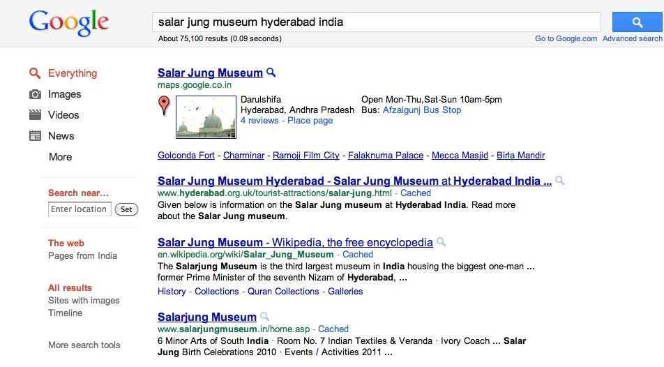
I was recently in Hyderabad for a meeting and had a couple of hours to spare. I always wanted to visit and know more about the famous Salar Jung Museum. I did a quick search on Google :
A click on the map link in the first result took me to the place page of the Museum on Google maps :
Place page has lot of information about the museum including the nearest public transit stop and an easy way to plan your trip
Click the “Directions” link below the address line
Enter your location or the place from where you need directions in the field “A”. For me it was “Hitech city Hyderabad” and click on the “Get Directions” button
Press on the bus icon (next to the car icon) and get the detailed trip plan using available public transit options
Alternatively, one can also get the directions by searching “Hitech city Hyderabad to Salar Jung Museum Hyderabad” directly on Google Maps. So next time whenever you are in Delhi, Mumbai, Bangalore, Chennai, Pune, Hyderabad or Ahmedabad, use Google Transit to plan your trip and help reduce emission and congestion in our cities.
Posted by Kapil Goswami, Business Development, Google India.
More people, in our metro cities, use local bus services to commute than any other transport network/medium. Inspite of this, the availability and dissemination of route and schedule information of these service have tremendous scope for improvement. Furthering our goal of expanding transit coverage of Indian cities, we are glad to announce the addition of DTC (Delhi Transport Corporation) and AMTS (Ahmedabad Municipal Transport Services) bus services to Google Transit. These cities join Mumbai, Bangalore and Pune bus services that are already available apart from 450 cities globally.
How to make the best use of Google Transit
Not only is it very easy to plan your trip, but you can also find a trip that involves a) fewer transfers b) less walking or c) uses a particular type of transit service (trains or buses), using Google Transit
Search for information to reach from Place A to B on Google Maps, the results will show a map with the possible route and driving directions for the commuter
Choose the transit option by clicking the train icon (next to the car icon)
Commuters would get first hand information on best available multi-modal routes and step by step directions including frequency, and travel duration for each leg of the trip in text and on the map.
You can also refine the trip options by clicking on the “Show Options” link that appear below destination point B field
Below is one example. You are visiting a friend who stays in Mayur Vihar phase I in Delhi and you would like to visit Red Fort using the bus.
Your friend instead suggests taking Delhi Metro to go to Red Fort and bus for the return journey. Its very easy to plan this using Google Transit, simply choose the preferred transit service to “Subway” and hit “ Get Directions” !
Before Google Map Maker—a product that enables people to add to and update the map for locations around the world—only 15 percent of the world’s population had detailed online maps of their neighborhoods. Using Map Maker, people have built out and edited the maps for 183 countries and regions around the world, and now, due to the contributions of citizen cartographers, 30 percent of people have detailed online maps of the places they live.
Map Maker users have mapped entire cities, road networks and universities that were never previously recorded online. These contributions have been incorporated into Google Maps and Google Earth, so the collective expertise of the Map Maker community benefits the millions of people using these products globally.
Today we’re opening the map of the United States in Google Map Maker for you to add your expert local knowledge directly. You know your neighborhood or hometown best, and with Google Map Maker you can ensure the places you care about are richly represented on the map. For example, you can fix the name of your local pizza parlor, or add a description of your favorite book store.
You can help make the map complete in other ways as well, such as marking the bike lanes in your town or adding all of the buildings on your university campus so they appear in Google Maps. We’ve seen incredibly detailed contributions from power users worldwide, including this comprehensive map of IIT Bombay. We’re eager to see you add the same level of detail to locations in the United States.
Indian Institute of Technology Bombay
To confirm Map Maker user contributions are accurate, each edit will be reviewed. After approval, the edits will appear in Google Maps within minutes—dramatically speeding up the time it takes for online maps to reflect the often-changing physical world. To see examples of what people around the world are adding to Map Maker, you can watch mapping in real-time.
In addition to opening Map Maker for the United States, we’ve added some new features for users globally. You can now get a street-level perspective on places with Street View imagery directly in Map Maker, see and edit all points of interest, and find exactly what you’re looking for with advanced search options such as displaying all railroad tracks.
Browsing all points of interest in downtown Palo Alto, California
Is your Mumbai experience authentic without having to hop a red BEST bus or having to board a crowded local train ? Its hard to imagine aamchi Mumbai without its trains and buses. Knowing that life in Mumbai revolves around trains and buses, it gives us immense pleasure to announce the availability of BEST Bus and Mumbai Local train routes and schedule information on Google Maps. This information is available both on desktop and on mobile for millions of commuters in Mumbai, arguably the most used public transportation network in India. Transit on Google Maps already includes information for Delhi Metro, Bangalore and Pune bus services in India in addition to 450 cities worldwide.
The easy access of this service helps commuters and tourists find their way seamlessly around the city using both trains and buses. As an example, here are the route options from Thane to Siddhi Vinayak Temple
How to use Google Transit ? It is very easy to plan your trip using Google Transit Search for information to reach from Place A to B on Google Maps
The result shows a map with the possible route and driving directions for the commuter
Choose the transit option by clicking the train icon (next to the car icon)
Commuters would get first hand information on available routes and the step by step directions including frequency, and travel duration for each leg of the trip in text and on the map.
I travel at least once in a month and have always wanted to take a bus to the airport. It’s hard to keep track of the schedules, find which bus to take and which bus-stop to board from. Starting today, commuters can find out bus schedules and routes for Bangalore Metropolitan Transport Corporation (BMTC) Vajra, Vayu Vajra and Big10 buses that ply across Bengaluru via Google Maps on desktop and mobile. The easy access of this service takes the uncertainty away and helps commuters find their way around the city using buses. As an example, here is the route from Airport to JP Nagar.
With a daily ridership of approximately 4.2 million passengers, BMTC is the first Indian Bus service to launch on Google Maps. BMTC and Google worked together closely to get the bus routes formatted in the General Transit Feed Specification and also align the bus routes to the actual roads on the map thereby delivering a better experience to users
Transit is now launched in over 500 cities around the world including Delhi where we partnered with Delhi Metro Rail Corporation earlier this year to launch Delhi Metro routes on Google Maps.
Ask for directions in India, and you'll notice most people tend to prefer landmarks over road names. These could be as simple as the "coffee shop past the third traffic signal" or a "petrol pump just past the Gateway of India".
We launched driving directions for India in April this year. Today we are taking this a step further with the launch of landmarks in driving directions.
This effort was possible thanks to the large amount of landmark data that users like you contributed through Google Map Maker. Our new algorithm determines from available signals, which of these landmarks are most useful for navigation, based on importance and closeness to the turns that you're making. We now combine landmark data, counted turns ("the 2nd right"), intersection names, and road names, and try to use whatever information is most relevant and useful for the direction you're heading in.
On the desktop, we're using landmarks in two ways - to identify where users need to turn, and to provide confirmation that they're on the right track. We have also included navigational landmarks on your mobile phone withGoogle Maps for Mobile.
We encourage you to help us improve the landmark data by sharing your local knowledge onGoogle Map Makeras we strive to build the best navigation mechanism for users in India. Just to give you an idea of what's new, the following screenshot helps you compare the before and after results for directions from IIM Bangalore to Bangalore City Railway Station Happy way-finding!
Posted by Sree Unnikrishnan, Sr. User Experience Designer and Manik Gupta, Product Manager, on behalf of a cross-functional and global Geo team


.png)
